Latitude and longitude serve as fundamental reference points used to describe positions anywhere on Earth. This coordinate system plays a vital role in maps, images, and navigation technologies. From GPS apps on your phone to geotagged travel photos, understanding how these lines work can improve both your online experience and real-world navigation.
What Are Latitude and Longitude?
Latitude and longitude are not real but conceptual lines used to help identify specific spots across the Earth’s surface. Together, they make up the geographic coordinate system.
- Latitude lines run horizontally from east to west. They help measure how far a location is from the Equator, either toward the north or south. The Equator divides the Earth into the Northern and Southern Hemispheres. Latitude readings start at 0° at the Equator and increase up to 90° as you move toward either pole.
- Longitude lines run vertically from north to south. They measure the distance east or west from the Prime Meridian (0°), which passes through Greenwich, England. Longitude values go from 0° to 180° east and west.
Each location on Earth has a unique coordinate pair, a combination of latitude and longitude that helps in pinpointing it precisely on a map.
How Latitude and Longitude Work in Maps and Coordinates?
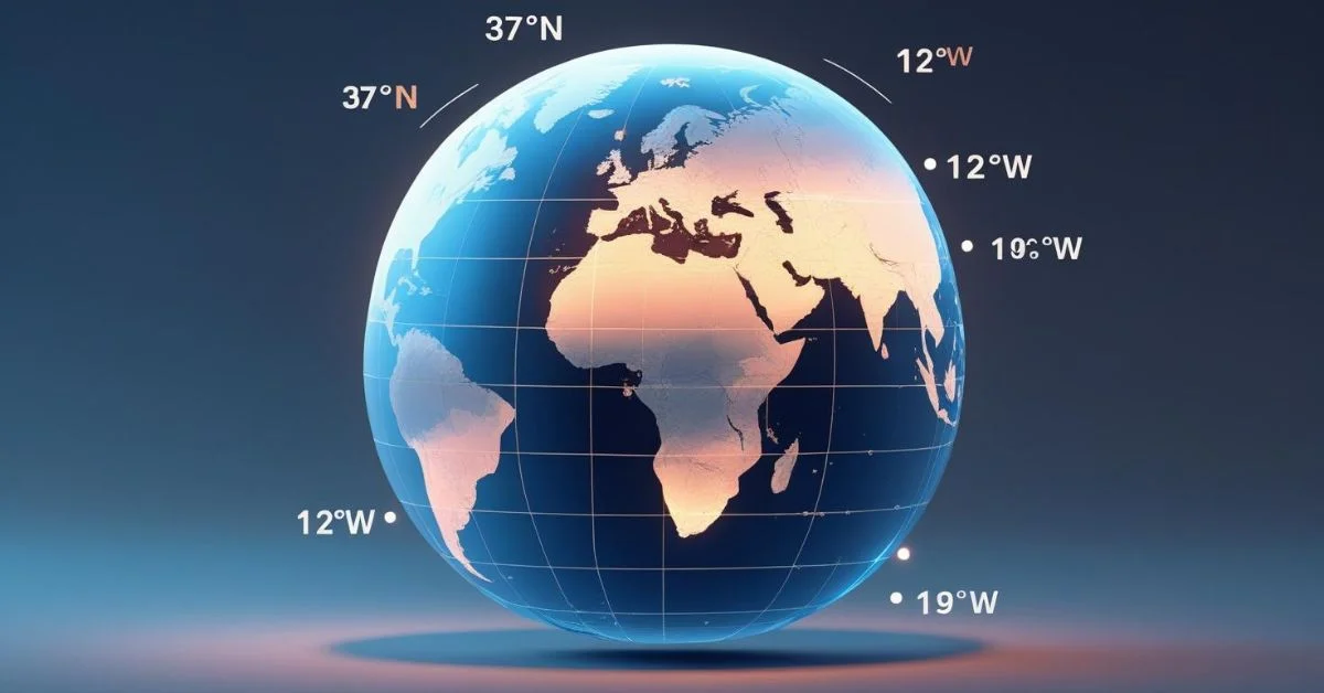
To organize the Earth’s surface, maps use a system of crossing lines called a coordinate grid or graticule. This grid of latitude and longitude lines is visible in many types of images, including globes, world maps and satellite views.
- On flat maps, latitude lines appear as horizontal stripes and longitude lines run vertically.
- On globes or 3D models, these lines form a mesh-like structure wrapping around the Earth.
These coordinate lines divide the world into manageable sections, making it easy to label, navigate, and study specific regions. When you look at digital maps or GPS systems, the information you see is powered by latitude and longitude coordinates.
How to Read Latitude and Longitude Coordinates?
Coordinates can be written in two common formats:
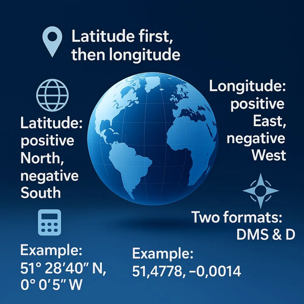
- Degrees, minutes and seconds (DMS): e.g., 51° 28′ 40″ N, 0° 0′ 5″ W
- Decimal degrees (DD): e.g., 51.4778, -0.0014
Key points:
- Latitude comes first, followed by longitude.
- Positive latitude values = north of the Equator; negative = south.
- Positive longitude = east of the Prime Meridian; negative = west.
These formats are used in a wide range of applications including mapping tools, navigation systems and geotagged images.
Common Uses of Latitude and Longitude in Daily Life
1. GPS Navigation
Latitude and longitude are the foundation of modern GPS. Whether you’re driving across town or flying internationally, navigation systems use these coordinates to give directions and real-time location tracking.
2. Latitude and Longitude Images in Mapping
Images and illustrations that show the Earth’s grid system help people understand geography better. These latitude and longitude images are often used in textbooks, apps and educational videos.
3. Weather Forecasting
Weather maps use coordinates to report accurate conditions for specific areas. Meteorologists rely on this grid system to track storms and predict weather patterns.
4. Travel and Tourism
When planning a trip, latitude and longitude coordinates help travelers pinpoint exact destinations. Popular places like tourist attractions, lodging options, and nature trails often include their exact location using coordinates.
5. Geotagging in Digital Media
Smartphones and digital cameras tag photos with the location they were taken. This is done using latitude and longitude, allowing users to sort, map and share memories with location accuracy.
6. Emergency Response and Safety
In remote areas, emergency responders use coordinates to find people quickly. Search and rescue operations depend heavily on accurate map coordinates.
7. Education and Earth Science
Educators and scientists use map coordinates to explore different natural patterns, such as climate regions, animal movements and shifts in the Earth’s surface. Maps that display latitude and longitude help students visualize global systems.
Real World Examples of Latitude and Longitude Coordinates
Here are some famous landmarks and their map coordinates:
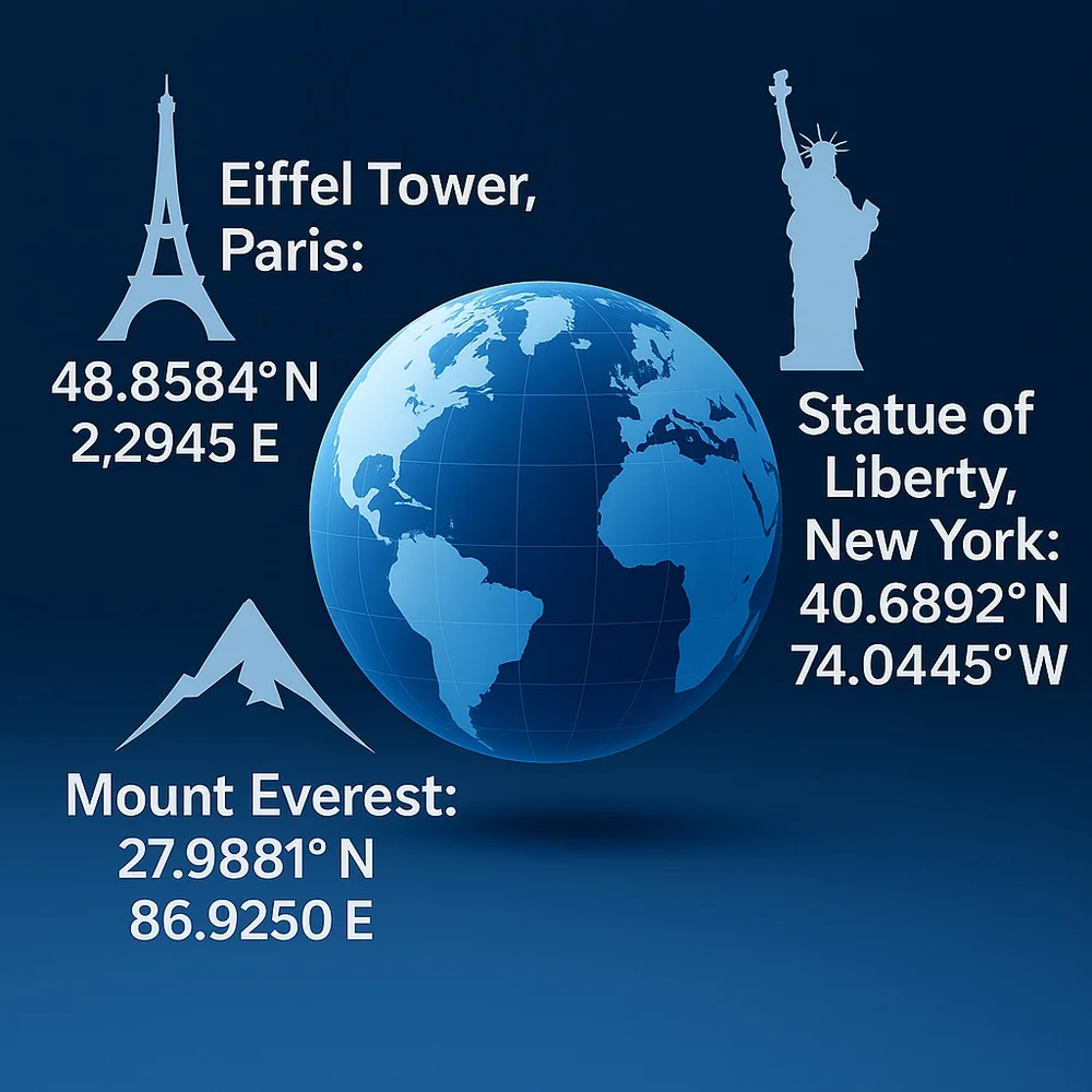
- Eiffel Tower, Paris: 48.8584° N, 2.2945° E
- Statue of Liberty, New York: 40.6892° N, 74.0445° W
- Mount Everest: 27.9881° N, 86.9250° E
Each of these places can be found precisely using latitude and longitude coordinates.
Why Latitude and Longitude Are Important?
Using this coordinate system has many benefits:
- Accuracy: Helps in locating even remote locations.
- Global Standard: Used worldwide in science, technology and communication.
- Versatility: Applicable in maps, drones, smartphones and educational tools.
From satellite images to simple map views, latitude and longitude help simplify how we explore, document and understand the world.
Map Projections and Coordinate Grids
Because the Earth is a sphere, flat maps must be adjusted, this process is called projection. Various map projection styles display the Earth’s grid (graticule) in unique ways depending on the method used.
- Mercator Projection: Common in web maps; great for direction but distorts size near the poles.
- The Robinson projection: offers a compromise between area accuracy and visual shape, making it more visually balanced overall.
- Globe Models: Offer the most accurate view but are not as convenient.
All of these show latitude and longitude lines, helping people interpret scale and direction.
Earth’s Division Through Coordinates
The Earth is split into northern, southern, eastern and western halves using its coordinate framework:
- Equator divides Northern and Southern Hemispheres.
- Prime Meridian divides Eastern and Western Hemispheres.
These divisions play a key role in setting time zones, defining seasonal patterns and managing climate-related systems. Coordinates also allow scientists to label climate zones and geographic boundaries.
Learning Through Latitude and Longitude Images
Visual aids like coordinate images help make geography more accessible:
- They show how lines wrap around the globe.
- They demonstrate location comparisons.
- They help learners visualize how navigation and mapping work.
Using these illustrations in teaching or travel planning makes the concept more practical and easier to understand.
Quick Fun Fact: Longitude and Time Zones
Each 15-degree section of longitude typically equals one hour of time change, which is why time zones align closely with these lines.
Maps & Coordinates in Everyday Use
Maps and coordinates are part of everyday applications:
- Ride-sharing apps use them to match drivers and riders.
- Delivery services track packages with coordinates.
- Hiking apps use GPS to help users follow trails safely.
Each of these functions depends on precise latitude and longitude data to operate correctly.
Conclusion
Latitude and longitude images, maps and coordinates are much more than academic concepts. They’re built into our smartphones, travel plans and digital maps. They’re part of how we share our lives, navigate cities and explore Earth.
By learning how latitude and longitude work and how they show up in maps and images, you gain confidence in using one of the world’s most useful tools. Whether you’re looking at a satellite view, reading map coordinates or using a navigation app, you’re engaging with one of the oldest and most important systems of human understanding.
Quick FAQs
1: What are latitude and longitude used for?
A: They are used to locate places on Earth in GPS systems, maps and satellite images.
2: How can I find coordinates on Google Maps?
A: To find the coordinates of a place in Google Maps, right-click on the spot and choose the option that says, “What’s here?” to see latitude and longitude.
3: Can I use coordinates without the internet?
A: Yes, many offline GPS apps allow you to enter coordinates manually.